AULIS (2012-2014)
Automated landslides inventory based on very high spatial resolution images
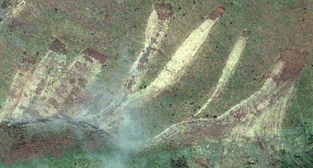
Landslides in Madeira island, just a few days after the flashfloods of February 20, 2010.
Project details
Funding organization
Fundação para a Ciência e a Tecnologia (FCT), contract PTDC/ECM/116611/2010
Period
September 2012 - August 2014
Principal Contractor
Centro de Recursos Naturais e Ambiente, Instituto Superior Técnico (CERENA/IST)
Participating Institutions
Laboratório Regional de Engenharia Civil da Madeira (LREC-Madeira)
Instituto Superior Técnico:
1. Instituto de Engenharia de Estruturas, Território e Construção (ICIST)
2. Instituto de Sistemas e Robótica (ISR/IST)
3. Centro de Estudos de Hidrossistemas (CEHIDRO(IST)
Principal Investigator
Pedro Pina (CERENA/IST)
Team members
CERENA/IST – António Jorge Sousa, Magda Matias, Pedro Pina, Sandra Heleno
LREC-Madeira – José Fernando Sousa, Sérgio Lopes
ICIST – Alexandre Gonçalves, Ana Paula Falcão
CEHIDRO/IST – António Betâmio de Almeida, Rodrigo Oliveira
ISR/IST- Margarida Silveira
Summary
Objectives
Landslides are a natural complex phenomenon characterized by slope movements of mass materials. This natural hazard, mainly triggered by heavy rainfall, earthquakes or rapid snowmelt, can cause significant damages to lives and infrastructures, being a major concern in many regions of the world where its extension and temporal frequency of occurrence are high. Thus, assessing landslide hazard through inventory maps is an essential primordial task for hazard zoning and risk management purposes.
The availability of an automated procedure capable of substituting the current semi-automatic approaches with manual verification surveys, would certainly be extremely useful and would have a strong impact in the natural hazard community, not only because it would be capable of rapidly generating landslide inventories with a high completeness degree, up to a dimension of less than ten m2, but also because it would provide the exact locations of those structures with much more accurate planar contours and the respective volumetric shape.
Thus, the main objective of this project is to develop an automated methodology based on object-oriented classification using very high spatial resolution images and high resolution topographic data, supported and validated by in-situ measurements, which should be able to deal with every and each type of landslide in order to rapidly produce and upgrade inventory maps.
Activities
For developing and testing our approach, we select the island of Madeira (Portugal), located at the top of a massive shield volcano with a particular relief of extremely steep slopes, where the incidence of numerous small and shallow landslides triggered by heavy rainfall is a major concern, making it an adequate region to develop and test our approach.
