HISURF2 (2013-2014)
Very high resolution imaging for detailed surface mapping in ice-free areas of Maritime Antarctica, part 2
Project Details
Financial and logistics support
Portuguese Polar Program (PROPOLAR), Korean Polar Research Institute (KOPRI), Programa Antártico Brasileiro (PROANTAR), Instituto Antártico Chileno (INACH),
Centro de Recursos Naturais e Ambiente (CERENA), Instituto de Geografia e Ordenamento do Território (IGOT), University of Vigo (Spain) and Federal Universiy of Viçosa (Brazil).
Campaign Period
January 2014 – March 2014
Participating Institutions
Centro de Recursos Naturais e Ambiente, Instituto Superior Técnico (CERENA/IST)
Instituto de Geografia e Ordenamento do Território, Universidade de Lisboa (IGOT/UL)
Universidade de Vigo (UVigo)
Universidade Federal de Viçosa, Brasil (UFV)
KOPRI - Korean Polar Research Institute (KOPRI)
Principal Investigator
Pedro Pina (CERENA/IST)
Team members
CERENA/IST – Lourenço Bandeira and Pedro Pina
IGOT/UL – Carla Mora and Gonçalo Vieira
UVigo - Julio Martín-Herrero and María Calviño-Cancela
UFV - Felipe Simas, Roberto Michel and Davi do Vale
KOPRI - Hyun-cheol Kim, Soon-gyu Hong
Summary
Objectives
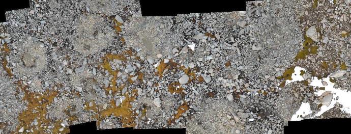
This project aims at the elaboration of high resolution mapping of ice-free regions of Antartica (namely in King George Island), in the continuation of the exploiting activities developed in 2013 within project HISURF from PROPOLAR. The level of detail of this cartography is fundamental to better evaluate the evolution of the landscape in one of the regions of the Earth where the climate changes are evolving faster, using remotely sensed imagery of very high resolution with own platforms and sensors in order to overcome the frequent atmospheric drawbacks and permit its swift acquisition in the narrow windows of opportunity.
Activities
In this campaign it is planned to acquire images with two platforms and two sensors in order to obtain complementary data at different scales and to collect ground-truth data and also soil samples. The processing of the several datasets, from the geometric corrections and mosaic construction until the building of the thematic maps of the target regions, will be performed after the campaign.
Objectives
This project aims at the elaboration of high resolution mapping of ice-free regions of Antartica (namely in King George Island), in the continuation of the exploiting activities developed in 2013 within project HISURF from PROPOLAR. The level of detail of this cartography is fundamental to better evaluate the evolution of the landscape in one of the regions of the Earth where the climate changes are evolving faster, using remotely sensed imagery of very high resolution with own platforms and sensors in order to overcome the frequent atmospheric drawbacks and permit its swift acquisition in the narrow windows of opportunity.
Activities
In this campaign it is planned to acquire images with two platforms and two sensors in order to obtain complementary data at different scales and to collect ground-truth data and also soil samples. The processing of the several datasets, from the geometric corrections and mosaic construction until the building of the thematic maps of the target regions, will be performed after the campaign.
Field campaign in images
To be published after the campaign. For the journal of the campaign, follow the blog of the project.
